

The Firth of Thames makes a complex case study for sea level rise. Parts of Thames, especially Moanataiari are subsiding quite fast (at a rate of 10mm/yr) because the suburb was built on reclaimed land in the 1970s. This more than triples the rate and amount of sea-level rise this area is experiencing. Also, much of this land was reclaimed using mine tailings. There is some community concern about the health of those living on top of this land, especially during floods.
Thames already has a seawall. Any floodwater that gets past this wall, such as during the 2018 storm (once considered to be a 1 in 100-year event) is pumped back out to sea.

Moanataiari beach and suburb – road flooding, beach loss and seawall overtopping during the January 2018 storm surge.
Screenshot from the NZ SeaRise Project Takiwā website of the Firth of Thames.
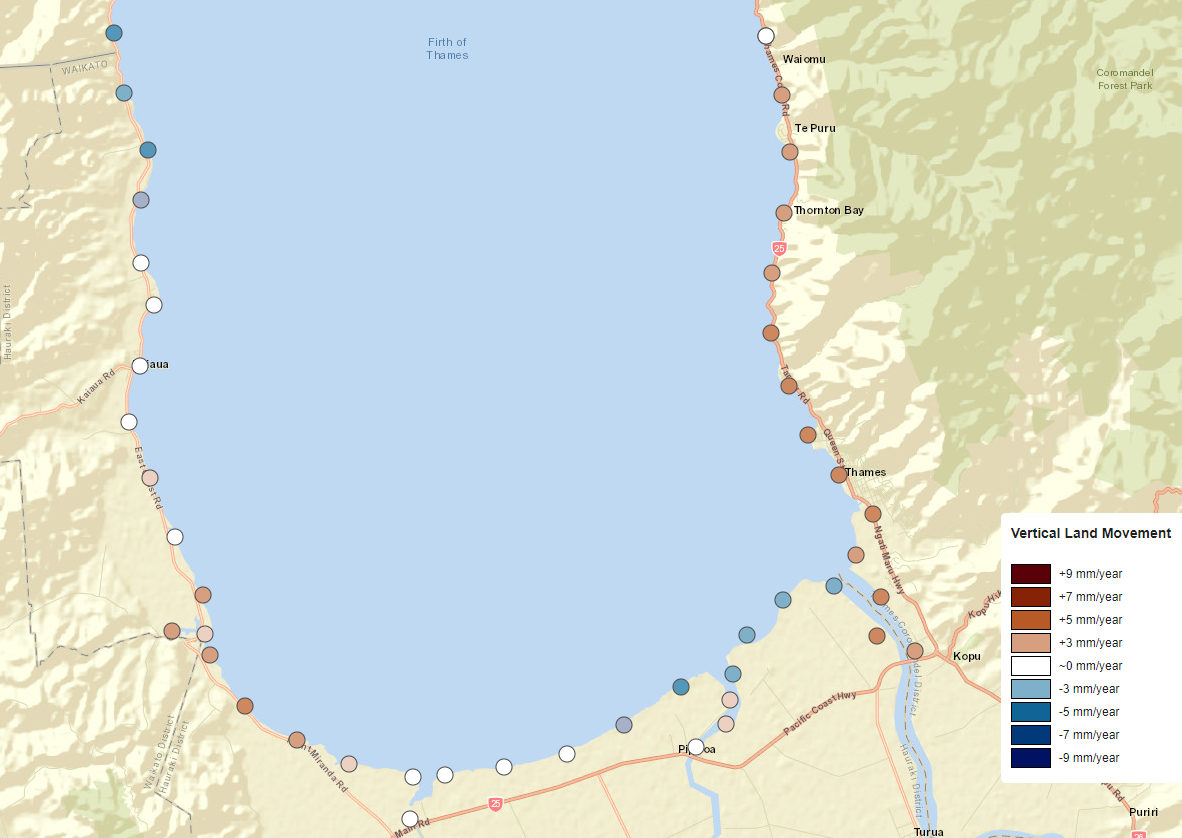
The Takiwā maps show an average rate of vertical land movement, uplifting Thames 2.35mm/year. In some parts of Thames however, such as Moanataiari, this average, which is based on measurements within a 2km square grid, doesn’t show that particular areas within that grid (e.g. Moanataiari) are subsiding at far quicker rates than the locations surrounding it. The next stage of our research will provide more granular information on vertical land movement (~100m spacing).
In January 2018, a deep low brought stormy weather to northern and central areas of Aotearoa New Zealand. Severe gales and heavy rain caused severe damage, particularly around Thames. There was also coastal devastation from the combination of low pressure, king tides and very strong winds. State Highway 25 north of Thames was ‘ripped apart’ and had to be rebuilt.
This 2018 storm was a “1 in 100-year” event. Without the Pipiroa and Kopu Bridges and State Highway 25 to the north, Thames is effectively cut off from the rest of the country. Damage to the Kopu Bridge from the Waihou River isolates the whole of the Coromandel. For 40cm of sea level rise, which will occur in this area by 2070 under even the best-case climate change scenario, the 100 year flood will be an annual event. Worse storms are also possible and may also be exacerbated by king tides.
Land reclamation during historic mining and since has destroyed much of the natural Mangrove sediment trap around Thames. More recently Mangrove was removed and a retirement village was built on reclaimed land that is subsiding.
West of the Waihi River, the Hauraki plains are subsiding at rates of up to 5mm/year due to tectonic subsidence and compaction from drainage of the peatland soils for dairy farming. This has required a scheme of flood bank protection, drainage channels and pumps.
Manaia Marae is located south of Coromandel township on the Coromandel Peninsula. Many hapū affiliate to this marae, including Ngāti Whanaunga and Ngāti Pūkenga ki Waiau of Hauraki. The wharenui is Te Kou o Rehua, and the wharekai is Ngairihanga. The marae ancestrally connects to the Tainui waka, the awa Teawa o Manaia and the maunga Horomanga and Hauturu. The marae is close to the Manaia River and is prone to flooding. For 40cm of sea level rise, which will occur in this area by 2080 even if we achieve the Paris target, the 100-year flood will be an annual event.

Thames-Coromandel Highway after the 2018 storm surge

Manaia Marae
The township of Thames, particularly the eastern side against the Coromandel ranges is being uplifted by tectonics associated with the Hauraki rift basin. Effectively anticipating and managing the impacts and risks of sea-level rise for the Thames area is complicated by highly varying rates of vertical land movement over the region.
Downtown Thames is at risk, though as you get closer to the hill the land is likely to rise over time, due to plate tectonics.
Stormwater and wastewater systems are particularly vulnerable in Thames. Floods can cause raw sewage to float through the streets, making clean-up extremely challenging and restricting opportunities for maintenance. Sea level rise will affect all coastal infrastructure, and as many of our water networks use gravity to discharge to water bodies, the costliest areas of the network are often located in low-lying areas or on the coast. From this, increasing sewage overflows, pipes corroded by salt water, and exposure to liquefaction are all likely. An increase in the severity and frequency of coastal storms will also cause increasing inundation, physical damage, and electrical failure at treatment plants.
As a tourism location, the Coromandel is also at risk, with tourists stranded in floods becoming more and more common.